
Lauderdale Lakes ZIP Coverage
Four standard ZIP codes touch this compact Broward city. Every one crosses a municipal border, and Fort Lauderdale is generally the USPS preferred city. The table describes the part of each postal zone relevant to Lauderdale Lakes, not an exclusive boundary. Confirm a specific address in the county parcel system.
| ZIP Code | Areas Covered | Post Office | Notes |
|---|---|---|---|
| 33309 | Northern and eastern edge; commercial and industrial corridor vicinity | Fort Lauderdale preferred city | Also reaches Oakland Park and other nearby cities |
| 33311 | Southeastern and eastern portions | Fort Lauderdale preferred city | Extends into Fort Lauderdale, Lauderhill, and Oakland Park |
| 33313 | Southern and western areas; Oakland Park Boulevard and NW 49 Avenue vicinity | Fort Lauderdale preferred city | Shared with Lauderhill and other western areas |
| 33319 | Northern and western areas; City Hall postal area | Fort Lauderdale preferred city | City Hall uses Lauderdale Lakes as an accepted mailing city |
No verified PO-box-only or unique institutional ZIP belongs exclusively to Lauderdale Lakes. All four are standard, shared routes. That fact matters because a ZIP-wide license, voter, or safety-registry result brings in addresses outside the city. The ZIP code directory must therefore be paired with BCPA's municipality field or a Broward GIS city-boundary layer.
Postal Names Versus Lauderdale Lakes
USPS answers whether an address can receive mail and which postal code routes it. BCPA answers which municipality contains a taxable parcel. A deed uses the parcel's legal description. Those are three separate systems. “Fort Lauderdale, FL 33319” can still point to land inside Lauderdale Lakes, while another 33319 parcel may fall in Lauderhill, Tamarac, North Lauderdale, or a nearby area.
The local street grid adds context but not proof. Numbered NW streets generally run east-west, while avenues generally run north-south. Curves, drives, terraces, condominiums, and subdivision plans interrupt that pattern. North State Road 7 and West Oakland Park Boulevard are strong location cues. Only a folio, situs, legal description, and mapped city boundary settle the jurisdiction.
Geography check. Lauderdale Lakes covers only 3.68 square miles, yet four nonexclusive ZIP codes cross it. Never substitute a postal border for the city line.
Search Lauderdale Lakes by ZIP
A ZIP code directory narrows thousands of Broward records, but it cannot finish the job. Follow this order so postal results do not import neighboring cities.
- Use the USPS ZIP lookup to validate the deliverable address and postal code. Treat the returned city name as mailing data only.
- Search the address in BCPA Property Search. Read the municipality, situs, folio, and legal description.
- Open the BCPA map and compare the parcel with the city boundary. Border streets and large shared postal zones need this step.
- For public voter analysis, use the state extract or a focused Broward SOE request, then filter both ZIP and municipality. Do not use the self-status form as a general directory.
- Once a valid city parcel is known, move to the Lauderdale Lakes directory by street for address-level ownership and record work.
Save the date and source of each result. Property and voter files change. A name attached to a license, business, permit, or recorded document may describe an office, applicant, contractor, or party rather than a household member.
Lauderdale Lakes Geography Search Fields
Each official source keys geography differently. BCPA works from a parcel. The voter file begins with legal residence and precinct. Official Records relies on names and legal descriptions. The ZIP value is useful, but secondary, in most of them.
| Source | Main Geography Key | How ZIP Helps |
|---|---|---|
| USPS | Deliverable mailing address | Authoritative postal ZIP, not municipality |
| BCPA | Folio, situs, legal description, municipality | Filter or parcel attribute |
| Official Records | Party, instrument, legal description | May appear in document text |
| Voter file | Legal residence and precinct | Sortable after exemptions |
| DBPR | Name, city, county, license type | Location filter for business records |
| FDLE registry | Address, city, county, ZIP, radius | Broad public-safety search area |
A ZIP-capable search should always preserve its role. A DBPR result in 33313 may be an office along Oakland Park Boulevard. An FDLE ZIP result covers the entire postal zone and uses reported registry addresses under that system's warnings. Neither result alone proves Lauderdale Lakes residency.
Lauderdale Lakes ZIP Voter Data
The Florida voter extract page publishes monthly active and inactive files with exempt fields removed. That is the appropriate broad public-data channel. The individual status tool needs a name and full birth date and is meant for a voter checking their own status.
The captured extract page below shows the official source for the file schedule and field layout.
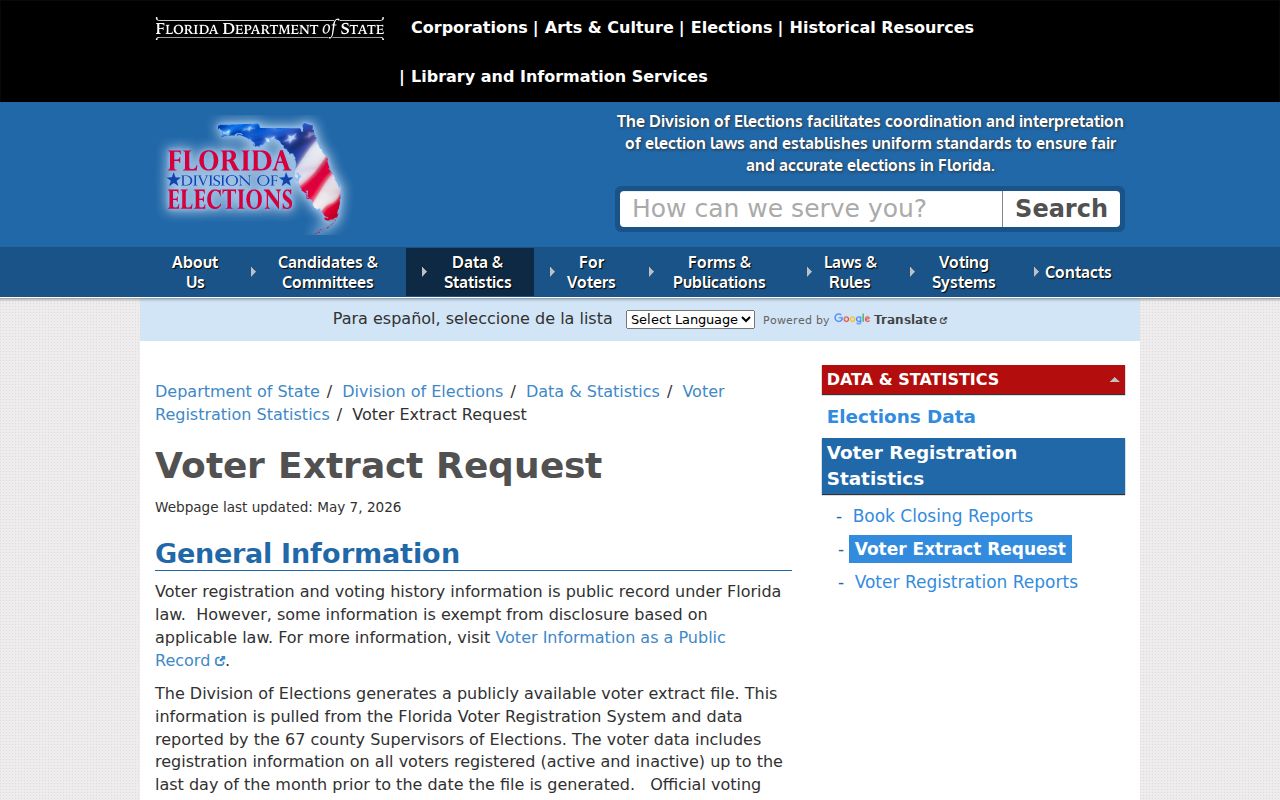
Public fields can include name, address, precinct, party, status, registration date, contact fields when supplied, and elections in which a voter took part. Ballot selections are never public. Protected addresses are absent, and registration does not cover every resident. Inactive status can reflect address-maintenance procedures rather than a completed move.
Four Lauderdale Lakes ZIP Profiles
33309 touches the north and east, including commercial or industrial corridor areas. Because the postal zone extends through Oakland Park, Fort Lauderdale, and other nearby communities, use the BCPA city filter before counting a parcel as Lauderdale Lakes.
33311 covers southeastern and eastern portions but continues into dense areas of Fort Lauderdale, Lauderhill, and Oakland Park. A court, newspaper, or license address bearing 33311 needs parcel-level confirmation. 33313 reaches southern and western parts of Lauderdale Lakes and a medical and commercial cluster near Oakland Park Boulevard and NW 49 Avenue. Business records in that ZIP should not be read as residential records.
33319 feels most local because Lauderdale Lakes City Hall uses it, yet it crosses into Lauderhill, Tamarac, North Lauderdale, Sunrise-area surroundings, and Fort Lauderdale postal naming. The ZIP code directory shows why even the city's best-known postal code is not a city-only list.
Radius Searches Around Lauderdale Lakes
The FDLE public registry supports city, county, ZIP, and neighborhood address-plus-radius searching. Names can be left blank for a location search, and partial names are accepted. It is a specific statutory public-safety tool, not a full resident directory. Its source data is reported and should be confirmed under FDLE's own cautions.
The captured registry interface demonstrates a ZIP-aware official search that extends beyond municipal borders.
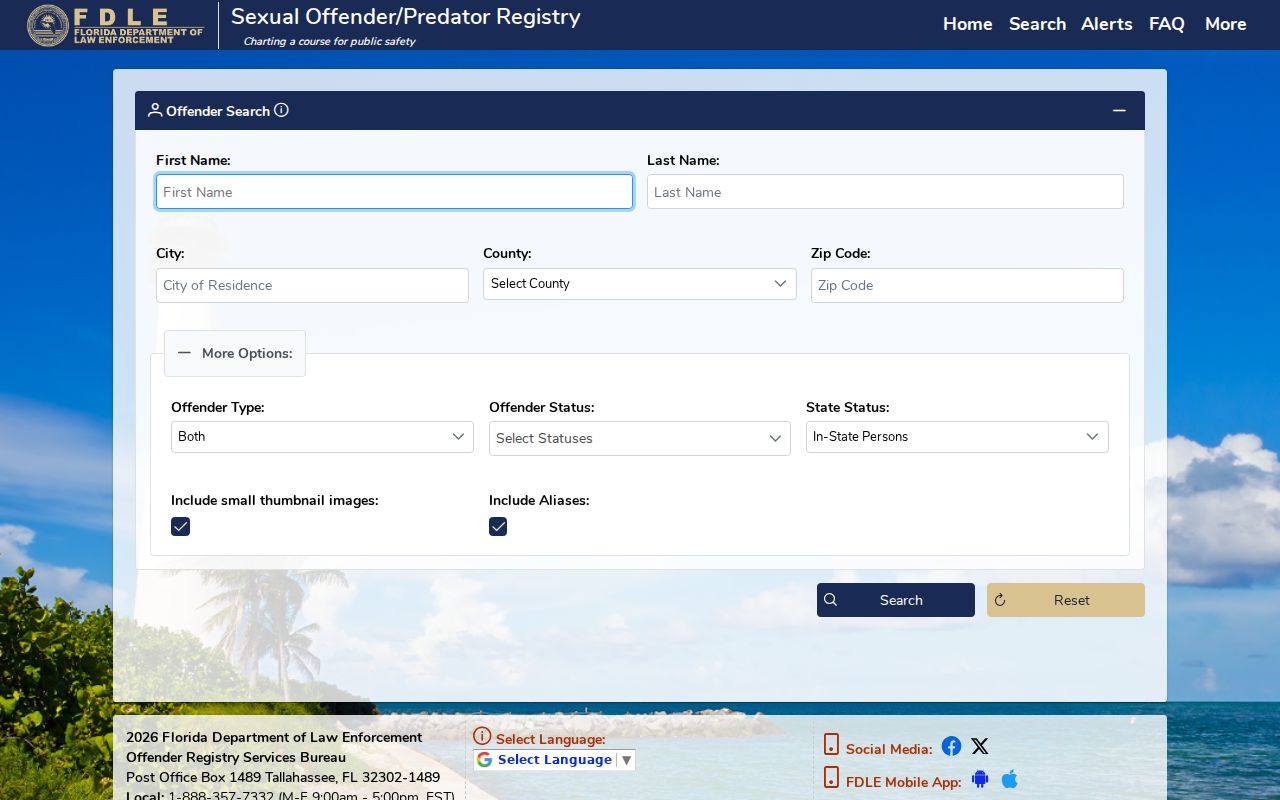
For immediate-block parcel work, BCPA Map is the better geographic tool. It shows adjacent polygons and links them to parcel cards. For voter questions, Broward SOE is the custodian. Match the system to the question rather than treating any ZIP filter as a complete population list.
Lauderdale Lakes ZIP Boundary Limits
Postal routes serve mail efficiently; they were not drawn to mirror Lauderdale Lakes. A city permit is strong evidence that the site falls under city jurisdiction, though the named applicant or contractor may live elsewhere. A deed remains tied to its legal description even if USPS changes a preferred city or ZIP. BCPA municipality and GIS provide the city test.
- ZIP versus ZIP+4
- A five-digit ZIP covers a delivery area; four added digits narrow a segment, building, or delivery point.
- PO-box ZIP
- A code assigned mainly to post-office boxes. None was verified as exclusive to Lauderdale Lakes.
- Unique ZIP
- A code assigned to one high-volume institution. None was verified for this city.
- Carrier route
- A smaller postal delivery path within a ZIP, still not a municipal boundary.
No official source identified a dated local ZIP split or citywide street renumbering. Do not infer one. Research a boundary change through city ordinances and Broward GIS. That restrained approach keeps the Lauderdale Lakes ZIP code directory tied to facts the official sources can support.